Difference between revisions of "Kent Towns and Villages G"
From the Family Tree Forum Reference Library
Darksecretz (talk | contribs) (Adding photo needed picture to missing places and aligning text) |
|||
| Line 12: | Line 12: | ||
</table> | </table> | ||
<br> | <br> | ||
| + | |||
<table cellpadding=10> | <table cellpadding=10> | ||
<tr> | <tr> | ||
| Line 20: | Line 21: | ||
*'''Holy Trinity''' Military Road, Old Brompton, Gillingham. Demolished | *'''Holy Trinity''' Military Road, Old Brompton, Gillingham. Demolished | ||
| + | <br> | ||
| + | |||
| + | ==Godmersham== | ||
| + | <table cellpadding=10> | ||
| + | <tr> | ||
| + | <td>[[Image:Deleted image.jpg|thumb|150px|]]</td> | ||
| + | </tr> | ||
| + | </table> | ||
| + | <br> | ||
| + | |||
| + | ==Goodnestone (Faversham)== | ||
| + | <table cellpadding=10> | ||
| + | <tr> | ||
| + | <td>[[Image:Deleted image.jpg|thumb|150px|]]</td> | ||
| + | </tr> | ||
| + | </table> | ||
| + | <br> | ||
| + | |||
| + | ==Goodnestone (Sandwich)== | ||
| + | <table cellpadding=10> | ||
| + | <tr> | ||
| + | <td>[[Image:Deleted image.jpg|thumb|150px|]]</td> | ||
| + | </tr> | ||
| + | </table> | ||
| + | <br> | ||
| + | |||
| + | ==Goudhurst== | ||
| + | <table cellpadding=10> | ||
| + | <tr> | ||
| + | <td>[[Image:Deleted image.jpg|thumb|150px|]]</td> | ||
| + | </tr> | ||
| + | </table> | ||
<br> | <br> | ||
| Line 37: | Line 70: | ||
</table> | </table> | ||
<br> | <br> | ||
| + | |||
==Gravesend== | ==Gravesend== | ||
<table cellpadding=10> | <table cellpadding=10> | ||
| Line 47: | Line 81: | ||
*'''St James''' Gravesend, Kent. Demolished 1969 | *'''St James''' Gravesend, Kent. Demolished 1969 | ||
*'''Holy Trinity''' Gravesend, Kent. Demolished 1963 | *'''Holy Trinity''' Gravesend, Kent. Demolished 1963 | ||
| + | <br> | ||
| + | |||
| + | ==Great Chart== | ||
| + | <table cellpadding=10> | ||
| + | <tr> | ||
| + | <td>[[Image:Deleted image.jpg|thumb|150px|]]</td> | ||
| + | </tr> | ||
| + | </table> | ||
| + | <br> | ||
| + | |||
| + | ==Great Mongeham== | ||
| + | <table cellpadding=10> | ||
| + | <tr> | ||
| + | <td>[[Image:Deleted image.jpg|thumb|150px|]]</td> | ||
| + | </tr> | ||
| + | </table> | ||
<br> | <br> | ||
| Line 56: | Line 106: | ||
</table> | </table> | ||
<br> | <br> | ||
| − | |||
| − | |||
==Groombridge== | ==Groombridge== | ||
| Line 63: | Line 111: | ||
<tr> | <tr> | ||
<td>[[Image:Kent, Groombridge, St John, Jill on the A272.JPG|thumb|150px|St. John. Submitted by Jill on the A272]]</td> | <td>[[Image:Kent, Groombridge, St John, Jill on the A272.JPG|thumb|150px|St. John. Submitted by Jill on the A272]]</td> | ||
| + | <td>[[Image:Kent, Groombridge, St Pius V RC, Jill on the A272.JPG|thumb|150px|St. Pius V RC. Submitted by Jill on the A272]]</td> | ||
| + | </tr> | ||
| + | </table> | ||
| + | <br> | ||
| − | <td>[[Image: | + | ==Guston== |
| + | <table cellpadding=10> | ||
| + | <tr> | ||
| + | <td>[[Image:Deleted image.jpg|thumb|150px|]]</td> | ||
</tr> | </tr> | ||
</table> | </table> | ||
<br> | <br> | ||
| + | |||
| + | <div align="left">[[#top|Back to Top]]</div> | ||
Back to [[Places of Worship:Kent]] | Back to [[Places of Worship:Kent]] | ||
Latest revision as of 07:43, 13 October 2020
Back to Places of Worship:Kent
Gillingham
- Holy Trinity Military Road, Old Brompton, Gillingham. Demolished
Godmersham
Goodnestone (Faversham)
Goodnestone (Sandwich)
Goudhurst
Grain
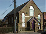 United Reformed Church. Submitted by Vikki Brace |
Graveney
Gravesend
- St James Gravesend, Kent. Demolished 1969
- Holy Trinity Gravesend, Kent. Demolished 1963
Great Chart
Great Mongeham
Greenwich
Groombridge
Guston
Back to Places of Worship:Kent
